This site is dedicated to my Masters project in Geology at Stockholm University.

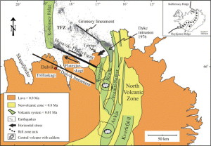
Image taken from Infrastructure and evolution of ocean-ridge discontinuities in Iceland. Copyright Ágúst Guðmundsson.
Stockholm University has been monitoring chemical changes in the water in two locations near the Húsavíkur-Flatey fault. Monitoring started at Húsavíkurhöfði, which is just a few meters from the fault, in 2002. In 2008 the second field site was added at Hafralækarskóli, 20 km to the south of Húsavíkurhöfði. Weekly samples are taken from both these sites and analysed at Stockholm University in Sweden. Changes have been seen in the water chemistry at these two places. In 2002 changes were seen up to 10 weeks prior to an M 5.8 earthquake and in 2012 and 2013 changes were seen 4 to 6 months before two >M5 earthquakes.
Currently the samples are taken by collecting water into sampling bottles that are then sent from Iceland to Sweden where they are analysed in an ICP at Stockholm University. This has meant that a few weeks or up to a year passes from the time the sample is taken until it is analysed and possible earthquakes have already occurred before the water chemistry data is available. So this current system can not be used for predicting or forecasting earthquakes.
My project looks at how this monitoring might be done in real-time.
In my project I am designing a network of observatories to be put into exciting low-temperature geothermal boreholes to monitor changes in water-level, temperature and conductivity in relation to earthquakes. The network will be located at the Tjörnes Fracture Zone (TFZ) in Northern Iceland and connected to the Earthquake monitoring system run by the Icelandic Meteorological Office (IMO). Data from these sensors will be delivered to the internet in real-time for scientist to use and analyse.
I believe that in order to successfully predict or forecast earthquakes we need to understand the physics behind these precursory phenomenon. Therefore we should measure as much as possible and look at the data gathered as a whole.

Image taken from the National Energy Authority website.
In Iceland geothermal is used to heat up about 90% of homes. Most of the space heating comes from low-temperature or tectonic geothermal boreholes. The high-temperature or volcanic geothermal boreholes are mainly used for generating electricity. From 1960 a lot of effort was put into finding geothermal zones in Iceland and as a result over 7000 boreholes are registered in the National Energy Authority a database.
The main part of my masters thesis is to find the best boreholes for monitoring changes in relations to earthquakes and what type of equipment is best suited for each site.
After I finish my Masters thesis I hopefully will be able to continue with this project as a job or a P.hd. or both.